The Name
The dam is built on almost level ground on the moorland plateau of Langfield Common. This was once a shallow marshy area drained by a stream which carved out Scar Clough - the deep gully opposite the Shepherd's Rest. Such marshy areas are called Ings in Yorkshire - an old Norse word for water meadow. Gadd is another Norse word meaning spike, which may refer to the spiky rock which is a prominent landmark on the skyline. Gadd was also an old English occupational surname for a cattle driver and Langfield Common was primarily used for grazing. Quarrying was another activity in the area and gadd was a word used for a quarrying tool. These speculations and many others surround the origin of the name Gaddings.
Construction
Gaddings Dam is a typical early 19th century embankment dam. It was built around 1833 by the engineers Jeremiah Jackson and John Backer to provide a reliable water supply for the mills of Lumbutts. The 1830s was a period when puddle clay was coming into use as an impermeable core and it is not known whether Gaddings has a puddle clay core or not. In fact little is known about the construction of the dam. The Gaddings Group have so far been able to find few records beyond the legal and financial articles concerning its construction.
A local engineer, Richard Stansfield, reported that the Dam was empty in the 1940s after the authorities disabled the outflow valve in the open position. At that time the reservoir was little more than a pond at most a metre deep. We have heard stories that youngsters playing at the dam would block the outflow as best they could to make the water deep enough to swim in.
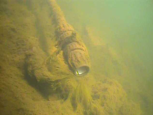
Outflow
Unlike modern dams which usually have a valve tower built out into the reservoir, the outflow from Gaddings (and other dams of that period) was via a scour pipe leading through the wall to a valve in the outflow culvert.
Scour pipes fell into disuse because they were often a source of weakness and a cause of failure. Fortunately for Gaddings, the draw down structure is particularly well built and remains in good condition with no indication of any seepage past the scour pipe. The intake to the scour pipe was permanently sealed in the 1960s by the engineer Richard Stansfield and the valve in the culvert is now closed. The valve itself is in poor condition and offers little hope of restoration.
Outflow from the culvert of the West dam was channeled via Scar Clough down to Lumbutts Road where it turned east along a stream to reach Causeway Mill. Water from the east dam ran east, down the Langfield Edge and through Horsewood tunnel into Black Clough where it supplied Lumbutts Mill and the mills along Lumbutts Clough.
Walls
The walls are generally in good condition except for the top of the gritstone cladding which has suffered from a good deal of vandalism over the decades.
The dam originally had a spray wall on three sides but this is long gone now. Consequently the reservoir has to be operated with rather less water than its original capacity. The accompanying picture shows the limited freeboard at high water in 2008. Since then the walls have been built up and a siphon installed and now there is an adequate freeboard.
Material for the walls almost certainly came from the large quarries on Langfield Edge just a few hundred metres away.
Catchment
Inflow to both dams came from two drains which run across the Common collecting water from the marshy plateau. Little water flows into the dam from the overgrown drains today and comparison of water levels with rain gauges shows that the catchment area of the dam is now hardly any more than the area enclosed by the walls.
Regulations
Gaddings Dam has to be operated in accordance with the regulations of the Reservoirs Act. This requires the Group to appoint a supervising engineer to advise on operation and maintenance. The supervising engineer inspects the dam at least once per year, and every 10 years the dam has a thorough statutory inspection from which a report is produced. Our last inspection was in 2015 and concluded 'The reservoir is in sound condition, is being well maintained and Undertakers are complying with the requirements under the Act' and also that 'The supervision provided by the undertakers is very good'.
Recent changes to the regulations require all dams to be classified as either 'high risk' or 'non-high risk' (there is no low-risk category) based on the potential for damage and loss of life resulting from failure. The category of Gaddings Dam has recently been assessed as high risk as are practically all impounding reservoirs with more than 25,000 cubic metre capacity. Reservoirs also now have to have a flood hazard category A to D where A is the highest. This relates to the potential for flood inflows. Gaddings with its very small catchment has been placed in category C.
Langfield Common is classified as a SSSI area and in addition to the Reservoirs Act, we have to comply with further regulations imposed by various agencies, which for example restrict the type of materials we can use for repairs.
Siphons
A 50mm siphon was installed in July 2008 to enable control over the water level. It discharges 160 litres per minute which would quickly fill a bathtub but takes about a week to reduce the water level by 2.9 cm.
The 50mm siphon is used during winter and spring to dump the winter rainfall.
Three additional siphon pipes were installed during February 2020 to provide an extra drawdown capability of 480 litres/minute per pipe. These are used during long periods of unusually high rainfall.
A short video of these siphons in operation: gd200301.avi.
Technical Data
| Water area: | 56,340 square metres |
| Average depth: | 2 metres |
| Maximum depth: | 4 metres |
| Perimeter: | 900 metres |
| Wave period: | 0.9 seconds |
| Altitude: | 355 metres |
| Visibility: | 3 metres (Winter), 50cm (Summer) |
| pH: | 4.7 |
| Total dissolved solids: | 18mg/litre |
| Outflow: | Siphon, up to 1500 litres/minute |
Water Level
The plot below shows the level relative
to the overspill into the adjacent empty (and discontinued) Gaddings East reservoir.
The beach is completely submerged at
a level of -110 on the chart.
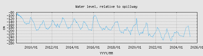 Since about 2020 we have operated the reservoir at a level about 80cm below the
2010-2020 levels. This creates a much larger beach and reduces the pressure on the dam
walls. The top quarter of the beach is now no longer submerged during Winter.
Since about 2020 we have operated the reservoir at a level about 80cm below the
2010-2020 levels. This creates a much larger beach and reduces the pressure on the dam
walls. The top quarter of the beach is now no longer submerged during Winter.
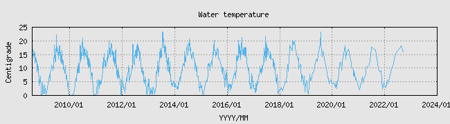
Water Temperature
The water temperature is mostly determined by the air temperature. Sunshine
gives a temporary warming of the top metre but this doesn't survive overnight.
Gaddings is shallow so the water responds quickly to
change of air temperature, especially so in high winds.
The water temperature is normally within a degree of
the mean of the daytime high and nighttime low air temperatures.
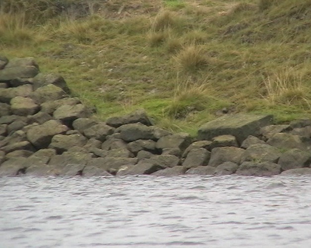
The Beach
The sand comes from weathered gritstone which is pushed into the north-east corner by the prevailing wind and waves. There is only about 10cm of sand, above gravel, which in turn covers the dark peaty clay of the reservoir floor. A good deal of sand is lost each winter as the wind picks it up and blows it right over the walls. Luckily there is plenty more to be brought in by the wind and waves. A small groyne is built out from the left of the beach which helps to catch the drifting sand and this produces a big increase in the size of the beach. Without the groyne, about a third of the beach would be gravel. Erosion of the embankment behind the beach from winter waves and summer visitors is an ongoing problem. Attempts to reinforce and repair the embankment are soon undone by visitors who pull out a stone to sit on.
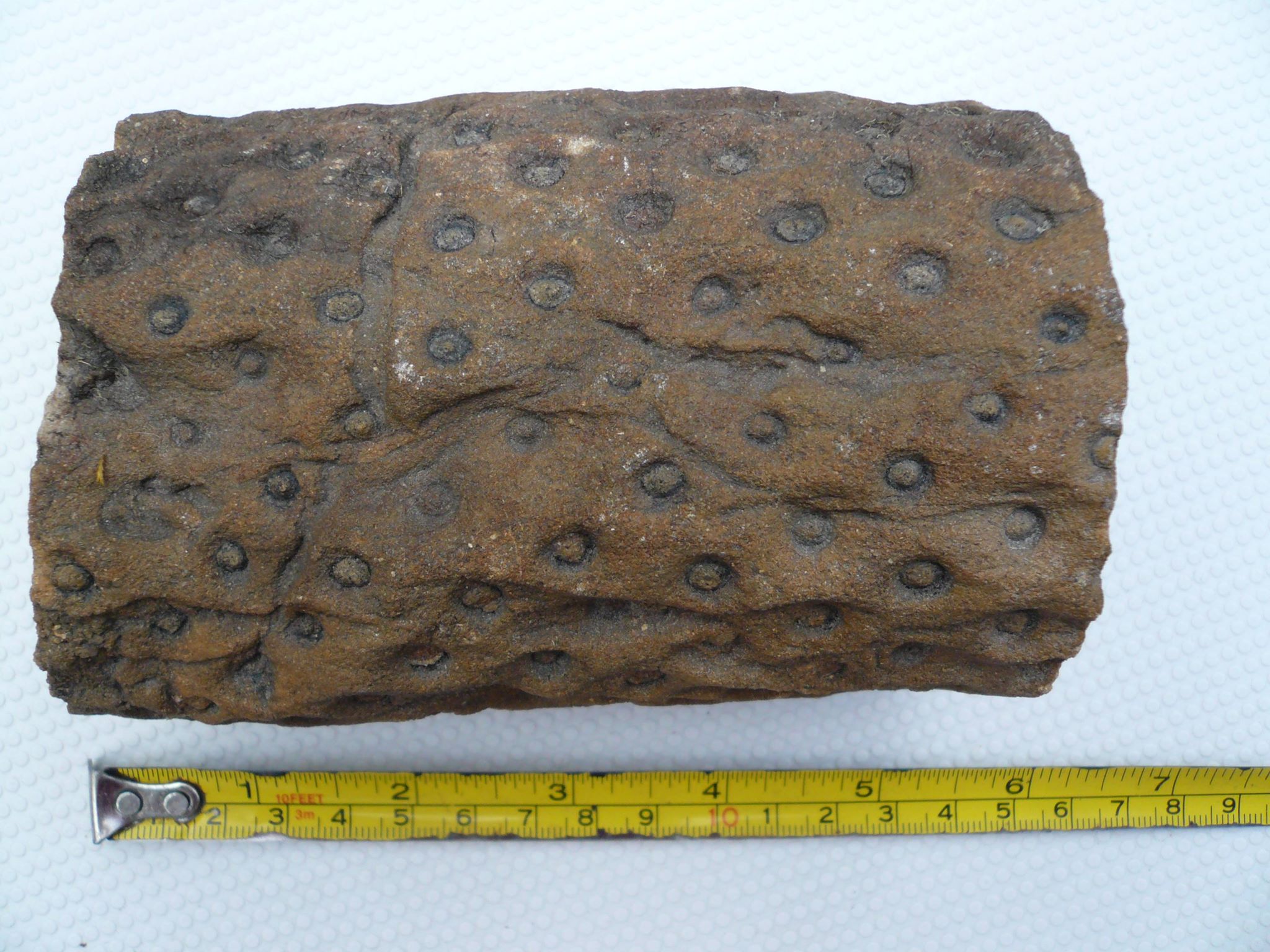
Fossils
The South Beach is a good place to find stigmaria fossils. These are the fossilised
rhizomes of Lepidodendron trees, some 300 to 360 million years old. Back then, the region
that would eventually be called Britain was near the equator and, as sea levels rose and fell
many times, cycled between beach sand, swampy forest and shallow sea. This deposited many
layers of sand, mud, silt, and dead trees. As the root systems of the trees rotted away, they
left behind tubes which then filled with mud to form the stigmaria fossils we find today.
The South Beach happens to expose a nice layer of these and you can also sometimes find the
fossilised sword-like Lepidodendron leaves.
Highest Beach?
The claim is often heard that Gaddings Beach is the highest beach in Britain or England. Neither is the case although this doesn't deter tabloid journalists and youtube videoists from perpetuating the claim. There are many high altitude tarns and lakes in places like the Lake District that have small sandy areas and many of these are much higher than Gaddings' modest 360 metres. Even Warland reservoir a mile to the South East has a slightly higher beach (a larger one too). Gaddings probably has the highest beach in Todmorden.