History of the Dam
Langfield Common
Gaddings Dam West, OS Grid Reference SD 948 224, lies in the heart of Langfield Common, an area of moorland above Lumbutts and Mankinholes in the Upper Calder Valley.
The moor's history as common land began during The Reformation. Its then owner, Sir Stephen Hamerton, a Roman Catholic, rashly rebelled against King Henry VIII not once (he was pardoned for his first offence) but twice. He was executed by hanging and beheading in 1537.
In time, the Crown awarded ownership of the common to itself. In a Royal Decree (recorded in 'An Exemplification of a Decree between the King and Priestley') dated November 25, 3rd year of the reign of James I (i.e. 1606), the Chancellor and Council of the Court found that the 'said moor or waste ground called Mankenholes otherwise Mankenholes Moor otherwise Mankenholes Edge is the King Majesty'.
The status of the Common as Crown property precipitated a system of tenure based on pasturing rights, expressed as 'gates' which can be sold or bequeathed. A 1912 reference to the gates states 'Fifty and a half cattlegates or pasturage for fifty and a half cows or other beasts of pasturage or a number of sheep or other cattle usually taken and accepted as and for and equal to the depasturage of fifty and a half cows and denominated by the name or term cattlegates in and upon and throughout the Common Moor or Waste Ground of and in the township of Langfield'.
The Construction of Gaddings Dam West
Dispute seems to have defined the origin of Gaddings Dam West too. The eastern-most dam, which is now empty and has been permanently breached by its owners, United Utilities, was the earlier of the two dams (east and west), and was built by the Rochdale Canal Company in the early 1800s to supply water to the canal in the valley below. This led to accusations from local mill owners that their all-important water supplies were being disrupted, and the Fielden Brothers purchased a moiety, or equal share, from the Canal Company some time before 1831. This allowed them to direct the water from the dam through their mill at Lumbutts before it passed down Woodhouse Clough on its way to the Rochdale Canal.
The Fielden Brothers (Joshua, John, James and Thomas) still required more water to power their new, triple water wheel at Lumbutts Mill, and in 1831 took neighbouring mill owners the Greenwoods (James and John) and the Uttleys (Young and William) to the Assizes in York demanding they share the cost of both enlarging the existing dam at Lumbutts Mill, and building the new dam at Gaddings. Despite the best efforts of the Fieldens' solicitor (James Stansfield), the case was referred to the arbitration of Philip Courtenay, barrister of the Inner Temple, London. On May 15, 1832, he published his award, specifying amongst other things that the Greenwoods and Uttleys should between them pay one third of the cost of building 'a good and sufficient new joint dam at an expense not exceeding...the sum of one thousand pounds', the first known reference to Gaddings Dam West.
The Fielden's also purchased land to build a tunnel, Horsewood Tunnel, to take water from the old, Gaddings Dam East into the enlarged Lumbutts Dam. An expenses claim from 1835 identifies the engineers for this work (Gaddings Dam West, Horsewood Tunnel, Gaddings Drain and the enlargement of Lumbutts Dam) as Jeremiah Jackson and John Backer.
Water was captured for both Gaddings Dams (East and West) from distant streams through the Gaddings Drain, and could be directed either down through the Horsewood Tunnel to Lumbutts, Greenwood's and Jumb Mills, or from the new dam down to Causeway Mill, which was also owned by the Fieldens.
The remains of a complex of sluice gates and waterways can still be traced on the moor land around the dams. The drain itself had nine stone bridges to allow livestock to pass freely.
The new dam was completed by 1835, and documents held in the Calderdale Archive Service include measurements of a plot of land belonging to Joshua Fielden 'at the top of the new dam, Langfield Common', from that year.
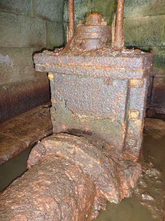
The design of the dam, with earth embankment walls and a valve set in a culvert is typical of the early 1830s. Earlier reservoirs had valves set outside the main walls or in short culverts, and later ones had valves in a tower inside the reservoir itself, more similar to modern water authority reservoirs.
The dam is reputed to have been built using convict labour from Manchester. Members of the Group have spoken to one of the warders at Strangeways Prison who had an interest in the prison's history. He told us that, at 1833 to 1835, the dam would have predated both Strangeways and Manchester's earlier jail, Bell Vue. He felt that if convict labour had been used it probably would have been from Salford House of Correction. Whatever the case, the existence of a quarry called Jail Hole Quarry close to the dam has been used to support this theory (although see Origins of the Name Gaddings), as has the fact that some of the stones in it still bear the Government arrow. Even so, the Group's research of the Fielden papers has uncovered no reference to the use of convict labour.
Langfield in 1848
In 1848, A Topographical Dictionary of England described Langfield as "a township, in the ecclesiastical district of Heptonstall, parish of Halifax, union of Todmorden, wapentake of Morley, W. riding of York, 11½ miles (W. by S.) from Halifax; containing 3284 inhabitants. It is partly situated in the picturesque vale of Todmorden, and comprises by computation 2620 acres, a large portion of which is common or moorland belonging to the freeholders, who depasture it in lots proportioned to the extent of their freeholds. There are quarries of good building-stone. The township includes the hamlets of Stoodley and Mankinholes, and also contains within its limits some scattered dwellings, forming a kind of suburb to the town of Todmorden. Its surface is boldly undulated, and the surrounding scenery is strikingly diversified. On the moor are two capacious reservoirs, one of which covers fifty three acres of ground, for the supply of the Rochdale canal and the various mills in the neighbourhood; and on a commanding eminence in the hamlet of Stoodley, called Stoodley Pike, is a lofty column erected in 1814, by subscription, to commemorate the restoration of peace throughout Europe. A fair for sheep is held at Lumbutts on the 11th of September. There are places of worship for dissenters." (A Topographical Dictionary of England, Samuel Lewis (editor), 1848).
The reference to a 53-acre reservoir is a mystery, in that the 1853 OS maps do not show any sizable reservoirs on Langfield Common. However, the 1851 OS maps of East Lancashire do mark both Blackstone Edge and Hollingworth reservoirs as 'to supply the Rochdale Canal', and the author may have been referring to one of these. With a combined surface area of under eight acres, the two Gaddings reservoirs are unlikely to have been described as 'capacious,' and the other reservoir referred to may have been Warland, a close neighbour of Gaddings, which was shown on the OS map of 1848, the year the Topographical Dictionary was published. There is also evidence, currently being researched, that Warland reservoir dates back to at least 1827, and was built by the Rochdale Canal Company.
Annals of Todmorden
The Annals of Todmorden, 1552 - 1913, compiled by Dorathy Dugdale, contains five references to Gaddings (or 'Gaddens', as it was often known).
On May 2, 1872, William Proctor, of Brook Street, Todmorden, who had been missing for some time, was found drowned in 'Gaddens Dam'.
On June 4, 1880, the G Company of Volunteers shooting range on Gaddings Flat, was declared open. Interestingly, the dam is supposed to have been used as a rifle range as recently as the Second World War, when the Territorial Army practised against its outer walls.
Harrowingly, at 3.45 in the morning of July 20, 1889, the bodies of three boys were recovered from Gaddings, having drowned whilst bathing. They were James Stevenson (12 years old), Abraham Crossley (10 years old) and Ernest Greenwood (9 years old). All were from Hollins.
On April 20, 1890, Gaddings was used as a venue for a prize fight between two men from Whitworth. Thirty six rounds were fought, with both combatants taking a bruising.
On March 17, 1894, at about 11.00am, the body of Edward Ogden, 57 years old, of Queen Street, Cobden, Todmorden, was removed from Gaddings. He had been missing for some days.
Modern History
The dam was certainly drained for periods during the 20th Century. One story is that the dam was emptied during the Second World War to prevent the Germans from using it as a navigation aid at night time, when the moon reflecting from its surface is apparently highly visible from the air. However, a letter from Todmorden's Borough Engineer, S. Greenwood, to the Town Clerk in 1943 states that both Gaddings Dams were empty at that time, adding 'that is, the position is the same as it was in 1933,' suggesting the dams had in fact been drained some time before the Second World War.
By the 1960s the valve mechanism had been disabled in the open position, and the reservoir was empty. A local engineer, Richard Stansfield, blocked off the outflow in the 1960s, allowing the dam to slowly refill. In fact, it took two years to fill completely, which gives some idea of what a limited catchment area supplies Gaddings (the catchment has been calculated as a maximum of 10 hectares).
Gaddings Dam West remained in the hands of the Fielden family until the 1970s, when the previous owner, John Slater, bought it. John had been responsible for saving Lee (or Lumbutts) Dam, and was an energetic local antiquarian with a particular interest in water and reservoirs.
Horsewood Tunnel
Long-forgotten by local people, Horsewood Tunnel was built in 1835 as part of a small network of water courses needed by the Fieldens to ensure an adequate water supply for their Lumbutts Mill.
We know from an expenses sheet that a cost of £110 3s 1½d was listed against the Tunnel on December 12, 1835, when the engineers Jeremiah Jackson and John Backer requested payment against 'work at Gaddings Dam, Drain, Horsewood Tunnel & Dam no. 2', the total cost of which to the Fieldens they gave as £879 13s 7d, with further contributions of £127 8s 11d from the Uttleys and £174 10s 4d from the Greenwoods (FLD: 316/1).
The lease and release agreements for the purchase of land adjacent to Lee (then Lumbutts) Dam survive, with the latter dated April 5 1834 for 'a plot of land parcel of Lee Estate in Langfield and Grant of privilege to make a tunnel under a close called Kiln Croft.'
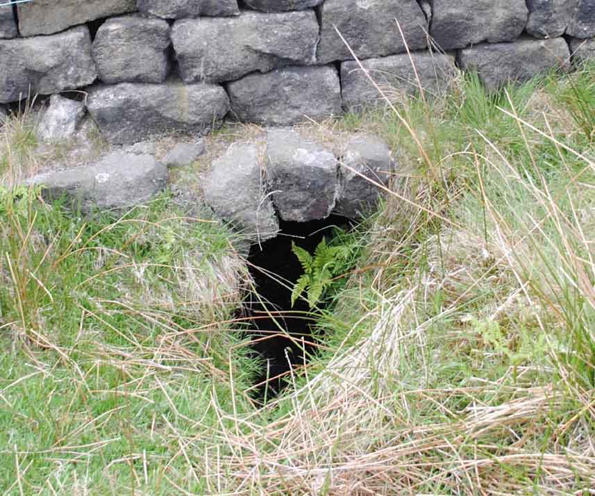
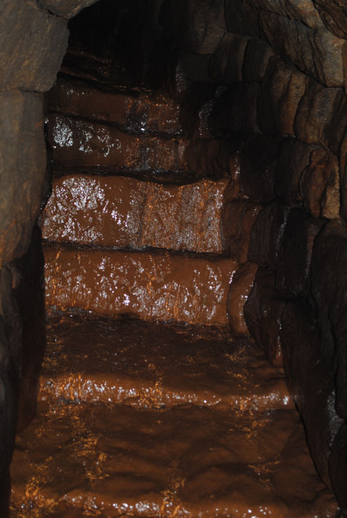
Members of the Gaddings Dam Group compared the 1853 OS map with modern maps and aerial photographs, and through this were able to discover both the entrance to and exit from Horsewood Tunnel, which Horsewood Water still flows through. The Tunnel is about 250 metres long. The entrance is built into the base of a wall, and could easily be mistaken for a drain or culvert. The exit is heavily overgrown, but can be entered by an adult, and discharges down a long stone-built culvert into a stream in the valley below, and through this into Lee Dam.